Street Planning and Grid Systems
37Signals had an interesting conversation about city planning and how streets are set up:
Utah does have a unique method of naming their streets. I used to live on Bard Lane, which sounds poetic in a Shakespearean sort of way, but in reality, it was 1325 West. Not so poetic now, huh?

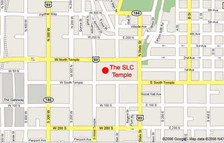
The numbering system stems from the Salt Lake City Temple. Like a piece of graph paper, the temple is (0,0) and all the numbers advance from there. North of the temple, the streets are named North Temple, 200 North, 300 North and so on. South of the temple, they are named South Temple, 200 South, 300 South and so on. East of the temple, they are named State Street, 200 East, 300 East, etc. West of the temple, they are named West Temple, 200 West, 300 West, etc.
So, when I lived at 8305 South Bard Lane (1325 West), I lived 8305 blocks south of the temple and 1325 blocks west of the temple. It’s a great system, even if you’re not LDS. After a few years of living here, you eventually forget that the founders of the town set up the temple as the center of the universe and just use the grid system to your advantage.
The grid system in Utah makes getting around the city a breeze. Next time you plan a visit to Salt Lake City (or any of the towns in Utah), take a moment to look at the map and understand the grid system. It will make your traveling much easier.